Seeing is believing

A vision to advance underwater inspection
Why are accurate and reliable observations of underwater structures and environments vital for the aquaculture industry? Many methods currently exist for obtaining underwater imagery, but most are not of sufficient quality to support precise measurement or consistent monitoring. Emerging techniques and technologies are now being developed that not only provide visually appealing models but also generate accurate and dependable data, giving confidence for important management decisions and regulatory reporting.
Tritonia Scientific is an underwater research and technology company, located near Oban, which brings together decades of commercial, scientific, and practical marine expertise to turn information gathered underwater into valuable intelligence for customers’ business needs.
Most of their work uses the technique of stereophotogrammetry that combines photos or videos to create 3D, highly accurate visual computer models. The surveys are planned with clients to meet the specific requirements of inspections and Tritonia can integrate data obtained from divers, ROVs, AUVs, side-scan sonar and aerial drones.
Precision and accuracy come from using:
• high-end through-water GPS systems for georeferencing;
• lasers or delineated markers for scaling and orientation; and
• salinity-corrected pressure sensors for depth measurement.
Tritonia can model objects over a range of sizes, from several kilo-metres across down to sub-millimetre scales. These can be presented in a format that is most useful for the client, from CAD models to layered GIS packages.
Tritonia makes the water disappear virtually, producing clear visibility even in turbid or low-light conditions. The models visually expose structures or environments that are not possible to see using traditional methods, producing permanent records that can be continuously assessed and used for whatever the client needs. Precise changes can be identified using comparison software on subsequent models which means that fewer surveys are often needed to show what is happening over time.
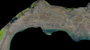
Beyond the initial survey requirements, Tritonia’s clients have found additional advantages of the models, including exact positioning as to where environmental samples, such as seabed cores, are taken or where invasive species have been identified during biosecurity surveys. In addition, low-tide aerial drone surveys can produce photogrammetric maps of broad-scale intertidal aquaculture resources, such the 47-hectare oyster farm shown in fig 3. These orthomosaic models display both location and shore elevation information.
Whatever the need for wanting to know more about what is underwater or close to the water, Tritonia Scientific is dedicated to revealing it all.


Captions:
Featured: A georeferenced model of a 12×12 m section of seabed produced where in-situ water clarity was 1-2 m.
1.: A Model: 136cm rock anchor (medium resolution). Used to measure: levels of biofouling, degree of anode sacrifice, depth of penetration, angle/direction of incline.
2.: A 47-hectare oyster farm

